Published June 30, 2023
Lake Levels in the Lake Norman and Charlotte Area

Elevate has many clients in search of their own piece of beautiful shoreline! We get so many questions about the ever changing lake levels and what to expect during different seasons and times of the year.
Whether you're enjoying that lake living life, appreciating the many amenities and activities, or just soaking in the local view, we have a resource for you.
Check out the screenshots below, and download this helpful app to get all of your lake updates from lake levels, to access information, and flow releases.
The Elevate Team utilizes this app regularly to keep our lakefront buyers in-the-know, or while out showing lakefront properties.


Some quick stats and facts we found interesting:
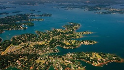
- Lake Norman was first flooded by the Catawba River in 1963 using a 130 foot hydroelectric dam
- It covers more than 32,000 acres, which used to be farmland, houses, buildings, and churches, and yes, cemeteries
- It boasts around 520 miles of shoreline, with water touching four counties
If you have any questions, feel free to contact us!
info@elevateREpros.com
(704) 800-6641

**Last updated 11/20/2020

Jeff Arzonico
Owner/Broker | Elevate Real Estate | EXP Realty LLC


or another way